The Search Panel
Overview Map
The Overview Map shows the entire map and indicates what part of the map is currently displayed in the main map.
- Show the Overview Map by clicking the Toggle Overview Map button on the tool bar or clicking the Overview Map header in the left panel.

- The red box on the Overview Map shows the area displayed in the main map.
- Click anywhere on the Overview Map to jump to that location on the main map. *Note: Use the Previous Extent (
 ) and Next Extent (
 ) buttons to move forward and backwards in your history of zooms and pans.
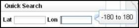
Quick Search
- If the Quick Search section isn't already open, click on the header in the left hand column labeled Quick Search.
- Enter your search term into the appropriate field and click the search button next to the search field or hit enter on your keyboard.
- The map will automatically zoom to the closest extent that allows you to see all of your results.
- If you are unsure of the format your search term should be in, a pop-up will tell you when you click in the empty field.

Advanced Search
Advanced Search works the same way Quick Search does, but it adds extra fields and parameters to allow you to refine your search more. *Note: Search terms will vary depending on your map theme.

Coordinate Search
The Coordinate Search lets you locate a point on the map by entering coordinates.
- Select the type of map you want to use: Google or Bing.
- Enter Lat/Lon, Local, or US National Grid coordinates.
- Click the search button next to the coordinates you entered. The map will zoom to the entered location.

Comparable Search
The Comparable search allows you to compare different features such as sale date, sale price, # of rooms, building material, etc. The features you are able to compare depends on your county/city's GIS data.
- Click on the identify base data tool (
 ) from the toolbar.
 - Select a feature you want to base your comparable search off of, such as sale price.
- Click the house icon (
 ) located under the layer Information panel. You will then see the Comparable Search options in the Search Panel.
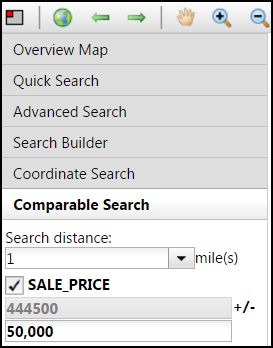
- Select the Search Distance from the drop down menu. The Search distance creates a 1, 2, or 3 mile radius to search for comparable features.
- Choose your appropriate search option by checking the box and entering the criteria in the text box.
- Click the magnifying glass to run the search.*Note: If you do not see the magnifying glass, move the scroll bar at the bottom of the comparable search section to the right.
Here is an example of the Comparable Search feature: If you have selected a Parcel with a sale price of $444,500 and you want to see the number of parcels that are within a 1 mile radius and have similar land values +/- $50,000, you would enter $50,000 in the text box. The search will then find every parcel within a mile radius that has a land value between $394,500 and $494,500.